|
|
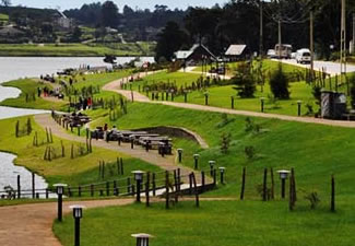
Nuwara Eliya is a city, in the hill country of the Central Province, Sri Lanka. The city name meaning is "city on the plain (table land)" or "city of light". The city is the administrative capital of Nuwara Eliya District, with a picturesque landscape and temperate climate. It is located at an altitude of 1,868 m (6,128 ft) and is considered to be the most important location for Tea production in Sri Lanka.
The city is overlooked by Pidurutalagala, the tallest mountain in Sri Lanka. Nuwara Eliya is also known for the temperate, cool climate, the city is known for being the coolest area in Sri Lanka. Due to its highland location, Nuwara Eliya has a subtropical highland climate (Köppen climate classification Cfb), with a mean annual temperature of 16 °C (61 °F). |
|
|
|
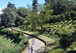
Hakgala Botanical Garden is situated on the Nuwara Eliya-Badulla main road, 16 km from Nuwara Eliya. The garden has a cool temperate climate because of altitude is 5,400 feet above the sea level. The mean annual temperature ranges between 16 °C to 30 °C during course of a year.[3] From December to February it has a cold climate, while the warm climate persists from April to August. History The garden was established in 1861 as an experimental cultivation of Cinchona, a commercial crop thriving at the time. Once after the Tea replaced the Cinchona, it was turned into an experimental Tea cultivation. In 1884 it transformed to a garden. Since then many sub tropical and some temperate plants were planted in the gardens. |
|
|
|
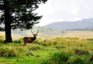
Horton Plains National Park is a protected area in the central highlands of Sri Lanka and is covered by montane grassland and cloud forest. This plateau at an altitude of 2,100–2,300 metres (6,900–7,500 ft) is rich in biodiversity and many species found here are endemic to the region. This region was designated a national park in 1988. It is also a popular tourist destination and is situated 32 kilometres (20 mi) from Nuwara Eliya and 8 kilometres (5.0 mi) from Ohiya. The Horton Plains are the headwaters of three major Sri Lankan rivers, the Mahaweli, Kelani, and Walawe. In Sinhala the plains are known as Maha Eliya Plains. Stone tools dating back to Balangoda culture have been found here. The plains' vegetation is grasslands interspersed with montane forest, and includes many endemic woody plants. Large herds of Sri Lankan sambar deer feature as typical mammals, and the park is also an Important Bird Area with many species not only endemic to Sri Lanka but restricted to the Horton Plains. Forest dieback is one of the major threats to the park and some studies suggest that it is caused by a natural phenomenon. The sheer precipice of World's End and Baker's Falls are among the tourist attractions of the park. |
|
|
|
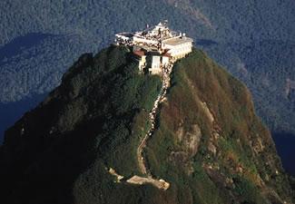
Adam's Peak "butterfly mountain", and is a 2,243 m (7,359 ft) tall conical mountain located in central Sri Lanka. It is well known for the Sri Pada, i.e., "sacred footprint",ArabicJabal Adam جبل آدم a 1.8 m (5 ft 11 in) rock formation near the summit, which in Buddhist tradition is held to be the footprint of the Buddha, in Hindu tradition that of Shiva and in Islamic and Christian tradition that of Adam, or that of St. Thomas.[1] In Islamic tradition it is the site where Adam fell to earth and where his footprint can be found.
|
|
|
|
|
|
|
|
|
|